 |
Sargent
is a small community located on the southeast Gulf coast of Texas. It's known for its' fishing, boating and beautiful beach. The population is approximately 500 permanent residents, but swells to high as 5,000 on weekends, especially holiday weekends. The village of Sargent is about five miles northwest of the Gulf of Mexico in Matagorda County. The town of Bay City is about 24 miles away. With its' ideal location near the Gulf, East Matagorda Bay, the Intracoastal Waterway and Caney Creek, Sargent is home to many commercial fisherman and shrimpers. The waterfront in Sargent is lined with homes, some dating to the 1950s and 1960s. Others are new homesites. The little community of Sargent Beach is an island separated from the mainland by the Intracoastal Waterway. There is only one main road on the island and the homes have great beach access. Sargent is called one of "Texas best kept secrets." On the beach, you can relax, take leisurely walks, have a picnic, go swimming, look for seashells, or even fish from the shore. Sargent has only one motel, a few campgrounds, and shops for the necessities, including a grocery store. There are several bait camps and marinas in town and a free public boat ramp. Sargent is the perfect little getaway for a weekend, a week or longer.

|
Sargent Vacation Rentals
|

|
|
|
|
|
Sargent Hotels and Resorts
|
|
|
| | | Hotels & Motels |
| Super 8 Motel | | Cabool, MO | 4.8 mi. | (417) 962-5888 | | Best Western Inn | 111 E 17TH St | Mountain Grove, MO | 13.6 mi. | (417) 926-3152 | | Americas Best Value Inn & Conference Center | 2105 Porter Wagoner Blvd | West Plains, MO | 23.1 mi. | (417) 256-2220 | | Holiday Inn Express | 1605 Imperial Rd | West Plains, MO | 25.1 mi. | (417) 257-3000 | | Super 8 Motel West Plains | 1210 Porter Wagoner Blvd | West Plains, MO | 25.5 mi. | (417) 256-8088 | | Best Western Grand Villa | 220 Jan Howard Expy | West Plains, MO | 26.6 mi. | (417) 257-2711 | | Pinebrook Lodge | 791 State Rt T | West Plains, MO | 26.6 mi. | (417) 257-7769 | | Way Station Motel | | West Plains, MO | 26.6 mi. | (417) 256-4135 | | Regency Inn & Suites | 1301 Preacher Roe Blvd | West Plains, MO | 27.0 mi. | (417) 256-8191 |
| | | Bed & Breakfast |
| Victoria Gardens Bed & Breakfast | 1461 State Rt BB | West Plains, MO | 26.6 mi. | (417) 256-3268 |

|
Sargent Weather & Climate
|

|
|
|
The Northern Gulf Coast of Texas , near the Louisiana border, has a humid subtropical climate. This region is actually located within the Piney Woods Region of eastern Texas. It receives the most rainfall in the state - more than 48 inches annually. This is due to the warm gulf waters that carry humid air to the region, where it condenses and precipitates. The area is also prone to hurricanes, the most disastrous of which was the Galveston Hurricane of 1900 as well as Hurricane Ike in 2008. Winters are mild due to the warm gulf currents. Wintry precipitation is possible, but rare. For instance, it snowed in the area in December, 2004 - the first occurrence since 1989. This region is cited as one of the most polluted urban areas in the U.S.
|
| Month |
High Temp |
Low Temp |
Rainfall |
Ocean Temp |
| January |
- |
- |
0.55 in. |
- |
| February |
- |
- |
0.84 in. |
- |
| March |
- |
- |
1.34 in. |
- |
| April |
- |
- |
1.88 in. |
- |
| May |
- |
- |
3.27 in. |
- |
| June |
- |
- |
3.28 in. |
- |
| July |
- |
- |
2.20 in. |
- |
| August |
- |
- |
2.79 in. |
- |
| September |
- |
- |
2.82 in. |
- |
| October |
- |
- |
1.68 in. |
- |
| November |
- |
- |
0.83 in. |
- |
| December |
- |
- |
0.66 in. |
- |

|
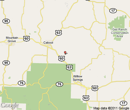
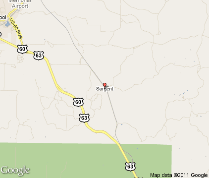
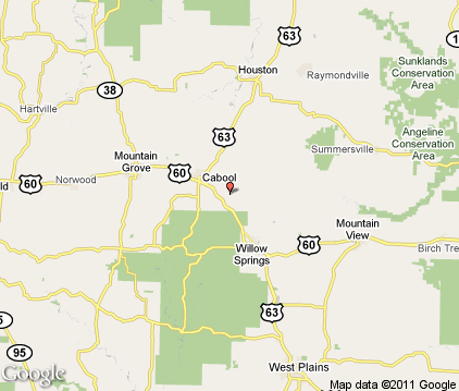
Sargent Map & Transportation
|

|
|
 |
|
|
| Click each thumbnail image to enlarge. |
 |
|
 |
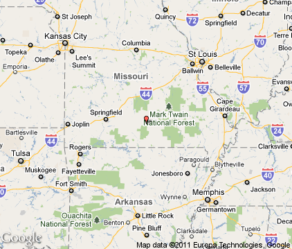 |
The closest airports in the area are the West Plains Municipal airport (UNO) located about 15 miles south of Sargent in West Plains, Missouri, the Mountain View airport (MNF) located approximately 18 miles southeast of Sargent in Mountain View, Missouri, the Floyd W Jones Lebanon airport (LBO) located roughly 51 miles northwest of Sargent in Lebanon, Missouri, the Baxter County Regional airport (BPK) located around 55 miles southwest of Sargent in Mountain Home, Arkansas, the Sharp County Regional airport (CVK) located about 62 miles south of Sargent in Ash Flat, Arkansas, the Marion County Regional airport (FLP) located approximately 63 miles southwest of Sargent in Flippin, Arkansas, the Rolla National airport (VIH) located roughly 73 miles north of Sargent in Rolla / Vichy, Missouri, the Springfield Branson Regional airport (SGF) located around 75 miles west of Sargent in Springfield, Missouri, and finally the Lee C Fine Memorial airport (AIZ) located about 75 miles northwest of Sargent in Kaiser / Lake Ozark, Missouri.
|

|
Sargent Attractions
|

|
|
| | | Amusement and Theme Parks |
| Celebration City | Branson | MO | 72.6 mi. | | | Silver Dollar City | Branson | MO | 72.6 mi. | | | BigShot Amusement Park | Linn Creek | MO | 75.7 mi. | | | Miner Mike's Adventure Town | Osage Beach | MO | 80.3 mi. | |
| | | Water Parks |
| White Water | Branson | MO | 72.6 mi. | | | Big Surf Waterpark | Lake Of The Ozarks | MO | 77.3 mi. | |
| | | Golf Courses |
| Wedgewood Country Club | Cabool | MO | 4.6 mi. | | | Randell Municipal Golf Course | Mountain Grove | MO | 13.2 mi. | | | Oakwood Golf Course | Houston | MO | 16.7 mi. | | | Dayne Glass Municipal Golf Course | Mountain View | MO | 19.2 mi. | | | West Plains Country Club | West Plains | MO | 27.1 mi. | | | West Plains Municipal Golf Course | West Plains | MO | 27.1 mi. | |
| | | State Parks |
| Montauk State Park | | MO | 31.6 mi. | | | Alley Spring State Park | | MO | 32.7 mi. | | | Round Spring State Park | | MO | 37.0 mi. | |
| | | Zoos and Aquariums |
| Dickerson Park Zoo | Springfield | MO | 70.5 mi. | |
Notice a problem with the information on this page? Please notify us.
|
Disclaimer: We recommend you conduct your own research regarding all accomodations and attractions found on this website. The distances shown on this website are straight-line distances as the crow flies. The road distance may be considerably longer. You assume all liability for use of any information found on this website. No information is confirmed or warranted in any way. By using our services you agree to the terms and conditions of this disclaimer.
|
| We are the #1 site for your Texas Vacations presenting Texas vacation rentals, hotels, weather and map for each city. |
Texas Vacations .com
©1997-2024 All Rights Reserved.
|
|